|
|
|
Whats in a name?
If you do an internet search for the word ‘Cassini’ you’ll probably come up with three main types of results: for a family of Franco-Italian mathematicians and cartographers; for a space mission to Saturn; and for a firm of historical map publishers. What’s the link?
We’ll try to explain.
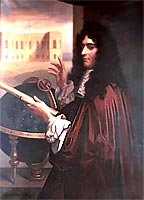 Giovanni Domenico Cassini
The Cassini story began in June 1625 when Giovanni Domenico Cassini was born in Perinaldo in the Republic of Genoa. He received a Jesuit education in the city and at one time considered taking holy orders, but instead became an astronomer and rose to the rank of Professor at the prestigious University of Bologna. He was also a mathematician, a part-time theologian, a builder and a surveyor: one of his commissions which must have involved all these skills was a short spell advising Pope Clement IX on the seemingly un-papal matter of military fortifications. Lured by professional advancement and the gloire of the Sun King’s court, he accepted an invitation to move to France in 1669. He was soon to become Director of the Paris Observatory, a post he was to retain until his death. So completely French did he become that he adopted the French version of his name, Jean-Dominique; although, as this was also the name of his great-grandson, he is known as Cassini I by those who have studied his family’s work. For convenience and brevity, these dynastic suffixes will be used here.
Cassini I’s astronomical observations and discoveries were considerable. Measuring the distance from the Earth to Mars by triangulation and then inferring the total size of the Solar System – and to within what has since been proved to be 6% accuracy – would have been enough for most 17th-century scientific careers. Yet he also created a table of the movement of Jupiter’s moons (used for the measurement of longitude at sea), drew an accurate chart of our own moon, identified several comets, and discovered many of Saturn’s moons. He also established that there is a gap between the two main parts of the rings around Saturn itself which is, in his honour, known as the Cassini Gap or the Cassini Division to this day. Hundreds of millions of miles of nothingness it may be, but its discovery was a triumph of scientific observation. This rational view of the universe was about to become the dominant intellectual force in Europe.
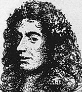 Jacques Cassini
Cassini I’s powers of observation were also put to the test closer to home. He realised that accurate astronomical observations demanded accurate measurements of the distances between the various observatories, measurement which were then sorely deficient. With the help of his son Jacques (Cassini II), he conducted accurate surveys of these particulars. Once started, such projects have the habit of growing towards their logical conclusion, and this was no different. Cassini I died in 1712, but Cassini II continued the work so that by the 1740s had produced what is recognised as the first accurate survey of the whole of France. He, like his father, became Director of the Paris Observatory. He too has a celestial feature named after him: an asteroid, now known as Jacquescassini as opposed to its previous and more prosaic name of 1999 VD9. He died in a carriage accident in 1759.
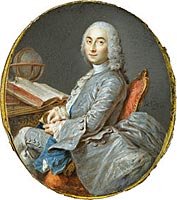 César-François Cassini de Thury
His son, César-François (Cassini III) continued the family tradition of becoming Director of the Paris Observatory, but it was from his cartographic work that his fame derives. In the 1730s he had become embroiled in a dispute with many opponents, including his father, about the exact shape of the earth, a view later vindicated by his triangulation work. Starting with the lines between a wooden belfry in Montmartre, a medieval castle and a farmhouse roof, he constructed a survey of the country which led to the publication in 1746-47 of a series of maps of France (18 sheets) at a scale of 1:870,000.
By this time, France was embroiled in a series of complex wars. Wars have the paradoxical effect of demanding accurate maps but also preventing the expenditure of time and money necessary for their creation. As a result, Cassini III’s work continued fitfully during the following decades. By the time of his death in 1783 only two of the eventual 182 sheets of his map of France had been published, although
the groundwork for the remainder had been laid.
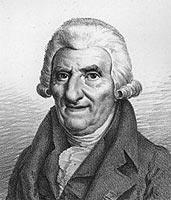 César-François Cassini
César-François’ son, Jean-Dominique (Cassini IV), had assisted his father in much of his later projects. His family’s connections with the Paris Observatory were by now effectively hereditary, with his father, grandfather and great-grandfather all having been its Director: Cassini IV was actually born in the building, on 30th June 1748, and it was therefore no great surprise when he in his turn became its Director on his father’s death. Despite this appointment, his main calling was, like his father’s, cartographic. He was determined to finish the task of mapping France that they had both begun. Eight years later, he presented the completed work (apart from two sheets of Brittany) to the National Assembly. By that time, though, forces were at work which would upset the secure world of patronage that he has his forebears had taken for granted.
A few years earlier, Cassini III had become involved in the Anglo-French project to calculate the respective positions of the observatories at Greenwich and Paris. Lurking behind this seemingly co-operative task was the goal of national pre-eminence in establishing one or the other as the prime meridian of 0º longitude. This operation also helped to lay the foundations of the work of the Ordnance Survey: after several decades of insular inaction since William Roy’s demands in the 1740s that a proper survey be conducted, the mapping of Britain had barely begun. The French Revolution had opposite effects on the two countries. The government in London realised the extent of the threat, and the deficiencies of their existing cartography, and bid the Board of Ordnance to start making maps of the southern coasts with all possible haste. In Paris, meanwhile, Cassini IV was reduced to pleading with revolutionaries not to destroy his scientific instruments and to watching impotently while they stripped the lead from the Observatory’s roof to turn into ammunition.
On 19 June 1791, Cassini IV and three colleagues had an audience with Louis XVI. Despite the more pressing national problems that even he could not have been unaware of, the king agreed to commission Cassini to undertake a series of surveys with the aim of establishing the exact value of a metre. It proved to be one of the last decisions of the Ancien Régime. The following day Louis made his infamous flight to Varennes and the revolutionaries were effectively in control of France. Cassini IV was unable to reconcile himself to the changes taking place around him. Most abhorrent to him were the abuses of science which were, in the interests of total reform and regeneration, being propounded for the measurement of space and time. “How can I recognise myself,” he fulminated in 1795, “in the changes they have wrought in our old ways of calculating our old measures, when we had not ten hours in a day, but twenty-four, and no circles of four hundred degrees?” Such sentiments contributed to his being jailed for several months during the troubles in Paris. Despite such setbacks, Cassini IV lived to a venerable old age and was able to witness from his estate in Thury the successive failures of the Revolution, the Napoleonic Empire and the restored Bourbon monarchy.
This brief history of the remarkable Cassini family – which doesn’t touch on the contributions made by numerous younger siblings and cousins – mirrors the equally remarkable history of France in these 120-odd years: scientific brilliance, belligerent innovation, grand state projects and dynastic reputation interrupted, but not destroyed, by revolution and war. Few families have produced four such formidable successive members, each of whom managed not only to continue the work of their predecessor but also adapt it to the changing needs of the time, in the process creating a body of astronomical and cartographical work that survives to this day. The fame of the Cassinis, I to IV, is assured and well deserved.
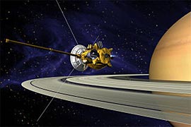 Cassini-Huygens
 Two centuries later, science had advanced, in ambition at least. In 1982, the American National Academy of Sciences and the European Science Foundation began discussing possible space missions to the outer solar system. Partly as a result of the geo-political considerations which have always attended US space missions – on this occasion the concern that the Europeans would choose to co-operate instead with the Russians rather than their ‘natural allies’ in North America – the collaboration survived various attempted budget cuts and abortions. Eventually, the Cassini-Huygens spacecraft (Christian Huygens was a Dutch astronomer and mathematician) was launched on 15 October 1997 from Cape Canaveral. Its principal aims were to establish details about the atmosphere, satellites and rings around Saturn; all objectives of which the Cassini family, Cassini I in particular, would have approved. After a long interplanetary voyage it entered into orbit around Saturn in July 2004, some eight years after its launch. Six months later, the Huygens probe landed on Saturn’s moon Titan. The project’s success in returning data to Earth has led to regular extensions of the mission, This is now expected to end in 2017.
About the time that the Cassini craft launched the Huygens probe towards Saturn’s largest moon, Cassini Maps was conceived in house in Berkshire. The two events were, we must stress, quite unconnected. Indeed, at the time the company had no name at all. Later, we hit upon one, and published 24 maps under this imprint. Unfortunately, it was then discovered that the name had been patented by someone else. Enquiries revealed that they were intending to plough a commercial furrow reasonably similar to our own and would not welcome any infringement of their use of name. A six-month period of grace was agreed for the situation to be remedied.
It was an ugly moment. The other company was quite within its rights and we bear no ill will. None the less, we were faced with needing not only to extend our coverage of maps but also to re-brand and reprint the ones we had already produced, and to pulp those original ones we could not sell within the agreed period.
In fact, it was a godsend. Close examination of the maps so far produced revealed glaring errors in the design, copy, naming and branding that thirty-odd combined years in publishing should never have allowed to happen. We had spend our creative energies on a genuinely difficult task: scanning, cropping, enhancing, edge-matching and – hardest of all – re-projecting Old Series Ordnance Survey maps and re-printing the results to match the present-day OS Landrangers. Everything else seemed easy and unimportant. We were wrong. A proper cover design, sensible series names and more appropriate text were all demanded. And, of course, a new name for the company.
This did not prove so easy. Each option was at first brilliant, but a few moments later seemed awful. Everything obvious appeared trite or else had been done before. Everything unobvious seemed pretentious or forgettable. Tempers frayed; inspiration failed; corporate confidence waned. If we couldn’t think of what we’re going to call ourselves, what chance did we have? Naming a baby is by comparison a far less onerous task.
Look at the choices. Something that unambiguously says what one does, such as ‘The Historical Map Company’, has advantages but generally lacks snap. The assertive ‘John Smith Mapping’ is another option, but presents problems when there are several partners with equal shares and different names. Words or phrases unconnected with the products (Apple, Next and Tesco spring to mind – whatever happened to them?) seem great ten years on if all has gone well but at the time need a big leap of faith. Finally, and most desperately, there’s the temptation of some nonsense name like Consignia, which with neither product nor proprietor nor pronounceability on its side is courting failure before the ink’s dry on the business cards.
So we had another think to narrow it down. We knew we were going to sell our maps to retailers and that we would have a website. Both considerations suggested a short, distinctive name that was easy to spell. A connection with maps and with history was important; a whiff of the exotic would do no harm. Above all, we had to be aware of what was already being used. Re-naming a company once due to a trademark confusion might be a misfortune; having to do so it twice – well, you often never get to hear about the third name, put it like that. We had to get it right this time.
 So, we hit upon Cassini. We’re happy with it. You have to admit it’s short and easy to spell. If you don’t get us mixed up with the Franco-Italian family or the spacecraft we’re also pretty distinctive. We’d be delighted if anyone suggested we possessed a fraction of the Cassini family’s qualities of resource, tenaciousness and innovation but we make no claim on this score ourselves. As for any connection with the spacecraft, you know what they say: the sky’s the limit... So, we hit upon Cassini. We’re happy with it. You have to admit it’s short and easy to spell. If you don’t get us mixed up with the Franco-Italian family or the spacecraft we’re also pretty distinctive. We’d be delighted if anyone suggested we possessed a fraction of the Cassini family’s qualities of resource, tenaciousness and innovation but we make no claim on this score ourselves. As for any connection with the spacecraft, you know what they say: the sky’s the limit...
Images from the Wikimedia Commons.
|