Cassini Maps Logo - High Quality Historical UK Mapping Old
Bacon County Maps

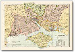
All the counties of England covered in this elegant collection of maps taken from Bacon’s Commercial and Library Atlas of the British Isles of 1900.

In his introduction to the Atlas, George Bacon was expressed the hope “that it will be pronounced unique and unrivalled, no such complete and extensive collection of Home Maps having hitherto been published. The Maps are all based on the latest Ordnance Surveys.” His confidence was justified; the maps stand today as accurate and elegant portraits of late-Victorian Britain from the time of the 1901 Census, and will prove fascinating to historians, genealogists and gift buyers; indeed to anyone with an interest in their county’s past.


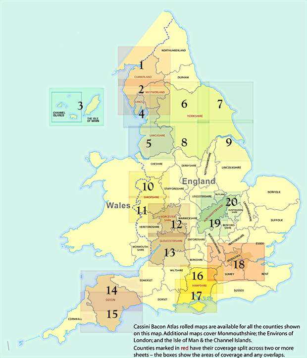
Choose the map you require
All maps taken from Bacon’s Commercial and Library Atlas of the British Isles of 1900
Cassini Bacon Atlas rolled maps are available for all counties shown below. Additional maps cover Monmouthshire, The Environs of London and the Isle of Man & the Channel Islands. Counties marked in red, on the map below, have their coverage split across two or more sheets - the boxes show the areas of coverage and any overlaps.
   
England & Wales  
Bedfordshire Environs of London (See map - box 18)
Berkshire Middlesex
Buckinghamshire Monmouthshire
Cambridgeshire Norfolk
Cheshire Nottinghamshire
Cornwall Northumberland
Cumberland- South (See map - box 2) Northamptonshire – North (See map - box 20)
Cumberland & Westmoreland - N (See map - box 1) Northamptonshire – South (See map - box 19)
Derbyshire Oxfordshire
Devon – North (See map - box 14) Shropshire - North (See map - box 10)
Devon – South (See map - box 15) Shropshire - South (See map - box 11)
Dorset Somerset
Durham Staffordshire
Essex Suffolk
Hampshire – North (See map - box 17) Surrey
Hampshire – South (See map - box 16) Sussex
Herefordshire Warwickshire
Hertfordshire Worcestershire & Gloucestershire – N (See map - box 12)
Huntingdon Worcestershire & Gloucestershire – S (See map - box 13)
Isle of Wight Wiltshire
Kent Yorkshire - North East (See map - box 7)
Lancashire – North (See map - box 4) Yorkshire - North West (See map - box 6)
Lancashire – South (See map - box 5) Yorkshire - South East (See map - box 9)
Leicestershire & Rutland Yorkshire - South West (See map - box 8)
Lincolnshire Channel Is & Isle of Man (See map - box 3)
   
 
Copyright © Heritage Resource Management Ltd.