Choose from:
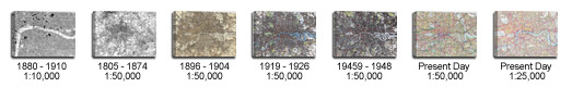
County Series 1:10,000 1880-1910 For over a century, Ordnance Survey’s County Series maps reveal the changing face of Britain in compelling and painstaking detail and now provide immaculate records for 21st-century researchers and historians.
Old Series 1:50,000 1805 -1874 These maps were the result of the first ever national survey of England & Wales. From the late 1790s until 1874, a small army of surveyors covered every corner of the what was still an almost entirely rural country.
Revised New Series 1:50,000 1896 - 1904 By the late 1890s, the Ordnance Survey had produced two complete series of maps of England & Wales but the increasingly rapid pace of change and development meant that revising them was now a never-ending task.
Popular Edition 1:50,000 1919 - 1926 The original Ordnance Survey Popular Edition series was conceived before, but published just after, the First World War. This was the first of Ordnance Survey’s series to be conceived from the outset as a mass-market product.
New Popular Edition 1:50,000 1945 - 1948 These maps reveal the reality of the outwards spread of urban populations with great clarity. For the first time, the areas covered by the series shows the build-up of towns and cities and their rapid expansion into the countryside.
Present Day 1:50,000 First published between 1974 and 1976, the printed form acquired the ‘Landranger®’ name in 1979. These maps have stood the test of time and remain the definitive survey of the country.
Present Day 1:25,000 Specifically designed for walkers and cyclists. The same mapping as used in the 'Explorer®’ maps. These are the most detailed leisure maps that Ordnance Survey publish and cover all types of footpaths and most details of the countryside for easy navigation.