Thetford & Diss HMG (1824-1922)
 |
|||||
|
|
|||||
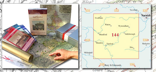
| Historical Map Gift Set (144) - Thetford & Diss HMG (1824-1922) This Historical Map Gift Set comprises:
|
More Details >>
| Cassini Maps | ||||||||
| Thetford & Diss HMG (1824-1922) | ||||||||
Thetford & Diss HMG (1824-1922) |
||||||||
More Details >> |
This map includes the following locations Anchor Corner, Arms, The, Ashill, Ashwellthorpe, Aslacton, Attleborough, Banham, Barford, Barnham, Barnham Broom, Barningham, Bawburgh, Beckett End, Besthorpe, Black Carr, Blo' Norton, Bobby Hill, Bodney, Botesdale, Bow Street, Bowbeck, Boyland Common, Bradenham, Brakefield Green, Brandon, Brandon Parva, Brandon Parva, Upper, Breckles, Bressingham, Bressingham Common, Brettenham, Brewers Green, Bridgham, Brock's Watering, Brook, The, Buckenham, New, Buckenham, Old, Bunwell, Bunwell Bottom, Bunwell Hill, Burgate, Burgh Common, Bush Green, Candle Street, Carbrooke, Cargate Common, Carleton Forehoe, Carleton Rode, Caston, Caudlesprings, Chalkhill, Church Green, Cockley Cley, Colton, Common, High, Common, Low, Common, North, Coney Weston, Cordwell, Coston, Crackthorn Corner, Cranwich, Cranworth, Cressingham, Great, Cressingham, Little, Crownthorpe, Crowshill, Croxton, Culfordheath, Daffy Green, Dam Green, Danemoor Green, Deopham, Deopham Green, Deopham Stalland, Didlington, Diss, Drurylane, Drymere, East Harling, East Wretham, Eccles Road, Edge Green, Ellingham, Great, Ellingham, Little, Elveden, End, North, End, South, End, West, Euston, Fakenham Magna, Fen Street, Fen Street, Fen Street, Fersfield, Fiddler' Green, Flaxlands, Forncett End, Frost Row, Fundenhall Street, Garboldisham, Garvestone, Gasthorpe, Goose Green, Great Cressingham, Great Ellingham, Great Green, Great Green, Great Hockham, Great Moulton, Green, Great, Green, Great, Green, High, Green, High, Green, Little, Green, Long, Green, North, Green, The, Griston, Hackford, Hale, Little, Hardingham, Hargate, Harling Road, Harling, East, Harling, Middle, Hepworth, Hethersett, High Common, High Green, High Green, Highoak, Hilborough, Hinderclay, Hingham, Hockham, Great, Holme Hale, Honington, Hopton, Hunt's Corner, Ickburgh, Illington, Ivy Todd, Kenninghall, Ketteringham, Kidd's Moor, Kimberley, Knettishall, Larling, Letton Green, Lings, The, Little Cressingham, Little Ellingham, Little Green, Little Hale, Little Melton, Long Green, Lopham, North, Lopham, South, Low Common, Low Street, Lower Stow Bedon, Lynford, Magpie Green, Manson Green, Market Weston, Marlingford, Marsh, The, Marsh, The, Mellis, Mellis Green, Melton, Little, Merton, Middle Harling, Morley St Botolph, Moulton, Great, Mount Pleasant, Mundford, Neaton, Necton, New Buckenham, Nordelph Corner, North Common, North End, North Green, North Lopham, North Pickenham, Northacre, Old Buckenham, Ovington, Palgrave, Penny's Green, Pickenham, North, Pickenham, South, Pockthorpe, Pooley Street, Pottergate Street, Puddledock, Quidenham, Ragmere, Redgrave, Reymerston, Rickinghall, Riddlesworth, Rockland All Saints, Rockland St Peter, Roydon, Runhall, Rush Green, Rushford, Saham Hills, Saham Toney, Santon Downham, Sapiston, Scoulton, Shadwell, Shelfanger, Shipdham, Short Green, Shropham, Silfield, Smallworth, Snetterton, Snow Street, South End, South Lopham, South Pickenham, Southburgh, Spooner Row, Stacksford, Stanford, Stanton Chare, Statland Common, Stonebridge, Stow Bedon, Stow Bedon, Lower, Street, Low, Stubbing's Green, Suton, Swaffham, Tacolneston, The Arms, The Brook, The Green, The Lings, The Marsh, The Marsh, Thelnetham, Thetford, Thompson, Thorpe Row, Thorpe Street, Thrandeston, Thuxton, Tofts, West, Toprow, Tottington, Upgate Street, Upper Brandon Parva, Walcot Green, Wattisfield, Wattlefield, Watton, Watton Green, Weeting, Welborne, Welbourne Common, West End, West Tofts, Westbrook Green, Westfield, Weston, Market, Wicklewood, Wilby, Wilney Green, Winburgh, Winfarthing, Woodrising, Wortham, Wramplingham, Wreningham, Wretham, East, Wymondham, |
This Version: |
| Thetford & Diss HMG (1824-1922) - HMG-144 |