Saxmundham, Aldeburgh & Southwold HMG (1837-1921)
 |
|||||
|
|
|||||
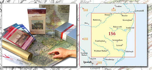
| Historical Map Gift Set (156) - Saxmundham, Aldeburgh & Southwold HMG (1837-1921) This Historical Map Gift Set comprises:
|
More Details >>
| Cassini Maps | ||||||||
| Saxmundham, Aldeburgh & Southwold HMG (1837-1921) | ||||||||
Saxmundham, Aldeburgh & Southwold HMG (1837-1921) |
||||||||
More Details >> |
This map includes the following locations Alburgh, Aldeburgh, Aldringham, All Saints South Elmham, Annis Hill, Apsey Green, Ashbocking, Ashfield, Ashfield Cum Thorpe, Ashfield Green, Aspall, Athelington, Audley End, Barham, Barnaby Green, Barnby, Barsham, Battlesea Green, Bedfield, Bedingfield, Benacre, Benhall Green, Benhall Street, Billingford, Black Street, Blacksmith's Green, Blaxhall, Bleach Green, Blyford, Blythburgh, Braiseworth, Bramfield, Brampton, Brampton Street, Brandeston, Bredfield, Bridge Green, Broadway, Brockdish, Brome, Brome Street, Bromeswell, Bruisyard, Brundish, Brundish Street, Bungay, Burgh, Burston, Bush Green, Butley, Carlton, Carlton Colville, Charsfield, Chediston, Chediston Green, Chillesford, Chippenhall Green, Clay Common, Clopton Corner, Coddenham, Coldfair Green, Colegate End, Cole's Green, Common, Great, Cove Bottom, Cove, North, Cove, South, Covehithe, Cranley, Cransford, Cratfield, Cretingham, Cross Street, Crowfield, Crown Corner, Cuckold's Green, Curlew Green, Dallinghoo, Darrow Green, Darsham, Debenham, Denham, Denham Corner, Dennington, Dennington Corner, Dennington Hall, Denton, Dickleburgh, Dickleburgh Moor, Dorley's Corner, Dublin, Dunwich, Earl Soham, Earsham, Earsham Street, East End, East Green, Eastbridge, Easton, Ellough, End, East, End, West, Eye, Eyke, Farnham, Fingal Street, Flixton, Foals Green, Framlingham, Framsden, Frenze, Fressingfield, Friday Street, Friday Street, Friston, Frostenden, Frostenden Corner, Garlic Street, Gisleham, Gissing, Glemham, Great, Glemham, Little, Goddard's Corner, Gosbeck, Great Common, Great Glemham, Green, East, Green, North, Green, North, Green, North, Green, North, Green, South, Gromford, Grundisburgh, Hacheston, Hacheston, Lower, Hales Street, Halesworth, Hardwick, Harleston, Hasketon, Heckfield Green, Helmingham, Hemingstone, Hemp Green, Henley, Henstead, Heveningham, High Street, High Street, High Street, Holton, Holton, Upper, Homersfield, Horham, Hoxne, Hulver Street, Huntingfield, Iken, Ilketshall St Andrew, Ilketshall St Lawrence, Ilketshall St Margaret, Kelsale, Kenton, Kenton Corner, Kessingland, Kessingland Beach, Kettleburgh, Knodishall, Langton Green, Laxfield, Leiston, Letheringham, Little Glemham, Little Whittingham, Lower Hacheston, Marlesford, Maypole Green, Mells, Melton, Mendham, Metfield, Mettingham, Mickfield, Middleton, Middleton Moor, Mill Green, Mill Green, Misery Corner, Monewden, Monk Soham, Mutford, Needham, North Cove, North Green, North Green, North Green, North Green, Oakley, Oakley Park, Occold, Otley, Page's Green, Parham, Peasenhall, Pettaugh, Pettistree, Piccadilly Corner, Pristow Green, Pulham Market, Pulham St Mary, Redenhall, Redisham, Redlingfield, Rendham, Rendlesham, Reydon, Reydon Smear, Ringsfield, Ringsfield Corner, Rishangles, Rumburgh, Rushall, Rushmere, Russel's Green, Saxmundham, Saxtead, Saxtead Green, Saxtead Little Green, Scole, Scole Common, Shadingfield, Shimpling, Shipmeadow, Sibton, Sizewell, Snape, Sneath Common, Sotterley, South Cove, South Green, Southolt, Southwold, Spexhall, St. Cross South Elmham, St. James South Elmham, St. Margaret South Elmham, St. Michael South Elmham, St. Nicholas South Elmham, St. Peter South Elmham, Stanway Green, Starston, Statford St Andrew, Sternfield, Stone Street, Stonham Aspal, Stoven, Stradbroke, Street, High, Street, High, Street, High, Street, Upper, Stuston, Sudbourne, Swan Green, Sweffling, Swilland, Syleham, Tannington Place, Theberton, Thelveton, Thorington, Thorndon, Thorpe Abbotts, Thorpeness, Tibenham, Tivetshall St Margaret, Tivetshall St Mary, Toad Row, Tunstall, Ufford, Uggeshall, Upper Holton, Upper Street, Upper Weybread, Wacton Common, Walberswick, Walpole, Wangford, Waterloo, Wenhaston, Wenhaston Black Heath, West End, Westhall, Westleton, Weston, Wetherup Street, Weybread, Weybread, Upper, Whittingham, Little, Wickham Market, Wilby, Willingham, Wingfield, Wingfield Green, Winston, Wissett, Withersdale Street, Witnesham, Wootten Green, Worlingham, Worlingworth, Wortwell, Wrentham, Yoxford, |
This Version: |
| Saxmundham, Aldeburgh & Southwold HMG (1837-1921) - HMG-156 |