Presteigne & Hay-on-Wye HMG (1831-1920)
 |
|||||
|
|
|||||
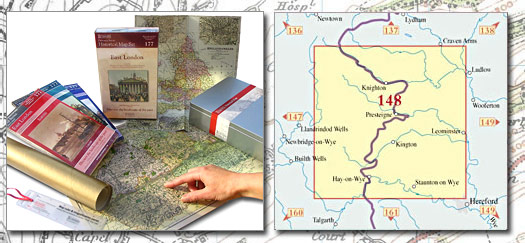
| Historical Map Gift Set (148) - Presteigne & Hay-on-Wye HMG (1831-1920) This Historical Map Gift Set comprises:
|
More Details >>
| Cassini Maps | ||||||||
| Presteigne & Hay-on-Wye HMG (1831-1920) | ||||||||
Presteigne & Hay-on-Wye HMG (1831-1920) |
||||||||
More Details >> |
This map includes the following locations Abcott, Adforton, Aldon, Aston, Barland, Batchcott, Beckjay, Bedstone, Beggar's Bush, Beguildy, Birtley, Blaenau, Bleddfa, Bradnor Green, Brampton Bryan, Brandhill, Brilley, Brilley Mountain, Bringewood Forge, Bromfield, Bronydd, Bryngwyn, Bryn-gwyn, Bucknell, Buckton, Bugeildy, Burlingjobb, Burrington, Bwlch y Plain, Bwlch-y-Plain, Cascob, Casgob, Castell-paen, Chapel Lawn, Chickward, Churchbank, Clifford, Clock Mills, Clungunford, Cnwclas, Colfa, Colony, The, Colva, Common, Little, Coxall, Craig Furuna, Cregrina, Crowther's Pool, Crug, Cwm, Cwm Aran, Cwm Heyop, Cwmaran, Discoed, Dolau, Dolley Green, Dol-y-cannau, Dolyhir, Downton, Dutlas, Duxmoor, Eardisley, Ednol, Eglwys Newydd, Yr, Elsdon, Elton, Evenjobb, Ferley, Field, Field, Old, Fishpools, Flintsham, Floodgates, Frank's Bridge, Gaer, Garreg, Garth, Gladestry, Glascwm, Glasgwm, Glog Hill, Gore, Gwaithla, Harpton, Harpton, Lower, Headbrook, Heartsease, Hengoed, Hergest, Lower, Hergest, Upper, Heyop, Heyope, Hobarris, Hopton Castle, Hundred House, Huntington, Invention, New, Kingswood, Kington, Kinnerton, Kinton, Knighton, Knill, Knucklas, Lady Halton, Lanlluest, Larch Grove, Leinthall Starkes, Leintwardine, Letton, Little Common, Little Merthyr, Llanandras, Llanbadarn Garreg, Llanbadarn-y-garreg, Llanbedr, Llanbedr Castell-paen, Llanbedr Painscastle, Llanbella, Llanbister, Llanddewi Ystradenni, Llanddewi-yn-Heiob, Llandeglau, Llandegley, Llanfair Llythynwg, Llanfair Waterdine, Llanfihangel Dyffryn Arwy, Llanfihangel Nant Melan, Llanfihangel Rhydieithon, Llanfihangel Rhydithon, Llanfihangel-nant-Melan, Llangunllo, Lloyney, Lower Harpton, Lower Hergest, Lower Rabber, Lower Todding, Lower Welson, Maelienydd, Maesyfed, Marlow, Merbach, Merthyr, Little, Michaelchurch on Arrow, Michaelchurch-on-Arrow, Milebrook, Millhalf, Milton, Monaughty, Monaughty Poeth, Mynd, Nash, Nether Skyborry, New Invention, New Radnor, Newchurch, Newman's Place, Newton, Norton, Obley, Old Field, Old Radnor, Onibury, Orleton Common, Painscastle, Panpunton, Parton, Pencraig, Penrhos, Pentre Hodre, Penybont, Pen-y-wern, Pilleth, Presteigne, Priors Halton, Priory Wood, Purlogue, Pwll-y-blaidd, Pyllalai, Rabber, Lower, Radnor, New, Radnor, Old, Rhiwlen, Rhos y Bont, Rhos-Crug, Rhos-goch, Rhos-grug, Rhos-y-meirch, Rhulen, Rhydspence, Richards Castle, Rockhill, Rodd, Rodd Hurst, Rushock, Shelderton, Skyborry Green, Skyborry, Nether, Slough, Stanner, Stanton Lacy, Stapleton, Stowe, Stowe, Sunset, The Colony, Thorn, Three Ashes, Todding, Lower, Trefyclawdd, Tref-y-Clawdd, Trefyclo, Tre'rdelyn, Treverward, Upper, Twitchen, Upcott, Upper Hergest, Upper Treverward, Upper Welson, Walford, Walton, Walton, Walton Green, Warden, Warren Bank, Welson, Lower, Welson, Upper, Weston, Weythel, Whitney-on-Wye, Whitton, Whitton, Whittytree, Wigmore, Willersley, Winforton, Wolfpits, Womaston, Woods, Wootton, Wootton, Wylde, Yardro, Yr Eglwys Newydd, |
This Version: |
| Presteigne & Hay-on-Wye HMG (1831-1920) - HMG-148 |