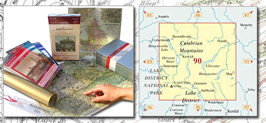
Penrith & Keswick HMG (1864-1925)
 |
|||||
|
|
|||||
| Historical Map Gift Set (090) - Penrith & Keswick HMG (1864-1925) This Historical Map Gift Set comprises:
|
More Details >>
| Cassini Maps | ||||||||
| Penrith & Keswick HMG (1864-1925) | ||||||||
Penrith & Keswick HMG (1864-1925) |
||||||||
More Details >> |
This map includes the following locations Ambleside, Applethwaite, Askham, Aughertree, Bampton, Bampton Grange, Bassenthwaite, Beckces, Berrier, Bewaldeth, Birkett Mire, Blencow, Great, Blencow, Little, Bomby, Boot, Bothel, Braithwaite, Braithwaite, Little, Branthwaite, Bridgend, Briery, Brigham, Brockleymoor, Buttermere, Butterwick, Caldbeck, Carleton, Castlerigg, Castletown, Catterlen, Chapel, Chapel Stile, Chestnut Hill, Clappersgate, Clifton, Cockley Beck, Crosthwaite, Great, Dacre, Dale Bottom, Dockray, Dubwath, Dykes, North, Eamont Bridge, Edenhall, Ellonby, Elterwater, Embleton, Fair Hill, Fell Side, Gatesgarth, Glenridding, Grange, Grasmere, Great Blencow, Great Crosthwaite, Great Salkeld, Great Strickland, Green Quarter, Green, High, Greystoke, Greystoke Gill, Hackthorpe, Haltcliff Bridge, Hartsop, Heggle Lane, Helton, Hesket Newmarket, Hewer Hill, High Green, High Hill, High Ireby, High Row, High Row, High Side, Hill, High, Howtown, Hutton, Hutton End, Hutton Roof, Ireby, Ireby, High, Johnby, Keld, Kentmere, Keswick, Kilnhill, Knipe, Low, Laithes, Lamonby, Langdale, Little, Langwathby, Lazonby, Legburthwaite, Little Blencow, Little Braithwaite, Little Langdale, Little Salkeld, Little Strickland, Little Town, Longlands, Longthwaite, Low Knipe, Lowther, Martindale, Matterdale End, Melkinthorpe, Millbeck, Millhouse, Morton, Mosedale, Motherby, Mungrisdale, Nether Row, Newbiggin, Newlands, Newlands, Newton Reigny, Newton Rigg, North Dykes, North Row, Ormathwaite, Orthwaite, Pategill, Patterdale, Penrith, Penruddock, Plumpton, Plumpton Foot, Pooley Bridge, Portinscale, Redhills, Rooking, Rosgill, Rosthwaite, Row, High, Row, High, Row, Nether, Row, North, Ruthwaite, Rydal, Sadgill, Salkeld Dykes, Salkeld, Great, Salkeld, Little, Scales, Scarness, Seathwaite, Seatoller, Shap, Side, High, Skelton, Skelwith Bridge, Sockbridge, Soulby, Southernby, Spring Bank, Stainton, Stair, Stonethwaite, Strickland, Great, Strickland, Little, Sunderland, Sweetholme, Swinside, Thornthwaite, Thorpe, Threlkeld, Tirril, Torpenhow, Town End, Town End, Town Head, Town Head, Town, Little, Townhead, Troutbeck, Troutbeck Bridge, Ulcat Row, Uldale, Ullock, Unthank, Upton, Wasdale Head, Watendlath, Waterfoot, Waterhead, Watermillock, Whale, Whelpo, Whitrigg, Woodend, Wreay, Wythop Mill, |
This Version: |
| Penrith & Keswick HMG (1864-1925) - HMG-090 |