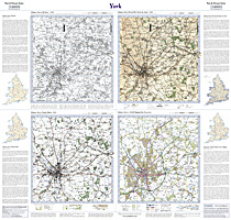
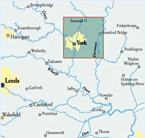
This map includes the following locations
Aberford,
Acaster Malbis,
Acaster Selby,
Ackton,
Acomb,
Airedale,
Allerton Bywater,
Allerton Mauleverer,
Angram,
Appleton Roebuck,
Askham Bryan,
Askham Richard,
Bank, South,
Barkston Ash,
Bates Hill,
Beal,
Beningbrough,
Bickerton,
Biggin,
Bilbrough,
Bilton,
Bilton Haggs,
Birkin,
Bishopthorpe,
Bolton Percy,
Boston Spa,
Bramham,
Brayton,
Broomhill,
Brotherton,
Burn,
Burton Salmon,
Byram,
Carleton,
Castleford,
Cattal,
Catterton,
Cawood,
Chapel Fields,
Chapel Haddlesey,
Chequerfield,
Church Fenton,
Church Garforth,
Clifford,
Clifton,
Cock Hill,
Colton,
Common, East,
Copmanthorpe,
Cowthorpe,
Cridling Stubbs,
Crockey Hill,
Cutsyke,
Darrington,
Dawker Hill,
Deighton,
Deighton Gates,
Dringhouses,
Earswick,
Earswick, New,
East Common,
East Garforth,
Eggborough,
Eggborough, High,
End, West,
End, West,
Fairburn,
Featherstone,
Featherstone, North,
Fenton, Little,
Fernley Green,
Ferrybridge,
Ferrybridge Hill,
Field, West,
Fryston, New,
Fulford,
Garden Village,
Garforth,
Garforth, East,
Gateforth,
Glass Houghton,
Gowdall,
Great Heck,
Great Preston,
Green Hammerton,
Green Hill,
Grove Town,
Haddlesey, West,
Hambleton,
Harewood Hill,
Haxby,
Healaugh,
Heck, Great,
Heck, Little,
Hensall,
Heslington,
Hessay,
Heworth,
High Eggborough,
Hillam,
Hirst Courtney,
Holgate,
Holme Green,
Hopperton,
Hunsingore,
Huntington,
Hut Green,
Hutton Wandesley,
Ingmanthorpe,
Kelfield,
Kellingley,
Kellington,
Kiddal Lane End,
Kippax,
Kippax Common,
Kirk Hammerton,
Kirkby Wharfe,
Knapton,
Knavesmire,
Knottingley,
Layerthorpe,
Ledsham,
Ledston,
Ledston Luck,
Lidgett,
Little Fenton,
Little Heck,
Long Marston,
Loscoe,
Lower Mickletown,
Lumby,
Marl Pits,
Marston, Long,
Micklefield,
Micklefield, New,
Micklefield, Old,
Mickletown, Lower,
Middlethorpe,
Milford, South,
Monk Fryston,
Monkhill,
Moor End,
Moor End,
Moor Garforth,
Moor Monkton,
Moor Monkton Moor,
Naburn,
Nether Poppleton,
New Earswick,
New Fryston,
New Micklefield,
New Town,
Newthorpe,
Newton Kyme,
Newton-on-Ouse,
North Featherstone,
Nun Appleton,
Nun Monkton,
Nunthorpe,
Old Micklefield,
Old Snydale,
Overton,
Oxton,
Parlington,
Pontefract,
Poole,
Poppleton, Nether,
Poppleton, Upper,
Potterton,
Preston, Great,
Racca Green,
Rawcliffe,
Red Hill,
Riccall,
Rufforth,
Ryther,
Saxton,
Scarthingwell,
Selby,
Sherburn in Elmet,
Shipton,
Skelton,
Snydale,
Snydale, Old,
South Bank,
South Milford,
St. John's,
Stillingfleet,
Strawberry Hill,
Street Houses,
Stutton,
Sutton,
Tadcaster,
Tancred,
Tang Hall,
Temple Hirst,
Thorp Arch,
Thorpe Underwood,
Thorpe Willoughby,
Thorpe Wood,
Tockwith,
Toulston,
Town, New,
Townville,
Towton,
Ulleskelf,
Upper Poppleton,
Walmgate Stray,
Walshford,
Walton,
Water Fryston,
West End,
West End,
West Field,
West Haddlesey,
Wetherby,
Wheldale,
Whitley,
Whitley Bridge,
Whitley Thorpe,
Whitwood,
Whixley,
Wigginton,
Wighill,
Willow Park,
Wistow,
Woodthorpe,
York,
|