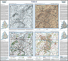
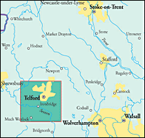
This map includes the following locations
Acton Trussell,
Adbaston,
Adderley,
Adeney,
Admaston,
Albrighton,
Allimore Green,
Allscott,
Almington,
Amerton,
Apeton,
Aqueduct,
Arleston,
Armsdale,
Ashfields,
Ashley,
Ashley Dale,
Ashley Heath,
Aspley,
Aston,
Aston-By-Stone,
Baldwin's Gate,
Barlaston,
Barrow,
Baswich,
Bearstone,
Beckbury,
Bednall,
Bednall Head,
Beech,
Beechcliff,
Beffcote,
Benthall,
Betton,
Bickford,
Billington,
Bishop's Offley,
Bishops Wood,
Blackbrook,
Bletchley,
Blists Hill,
Blore,
Bloreheath,
Blymhill,
Blymhill Lawns,
Bolas Heath,
Bolas, Great,
Boscomoor,
Bowers,
Bowling Green,
Bradley,
Bratton,
Brazenhill,
Brewood,
Bridgefor, Little,
Bridgeford, Great,
Bridgetown,
Brineton,
Broad Heath,
Brockton,
Brockton,
Brockton,
Brocton,
Bromley Hall,
Bromstead Common,
Bromstead Heath,
Brookside,
Broseley,
Broseley Wood,
Broughton,
Brownhills,
Buildwas,
Burnhill Green,
Burston,
Burton Manor,
Burybank,
Butter Bank,
Calf Heath,
Calverhall,
Cannock,
Castletown,
Cat's Hill Cross,
Chadsmoor,
Chadsmoor, West,
Chadwell,
Chapel Chorlton,
Charnes,
Chatcull,
Chatwell, Great,
Chebsey,
Cherrington,
Cheswardine,
Cheswell,
Chetwynd Aston,
Chetwynd Park,
Childs Ercall,
Chipnall,
Church Aston,
Church Eaton,
Churchbridge,
Cluddley,
Coalbrookdale,
Coalmoor,
Coalport,
Cobscot,
Codsall Wood,
Cold Hatton,
Cold Hatton Heath,
Coldham,
Coldmeece,
Common, The,
Compton, Long,
Congreve,
Conquermoor Heat,
Coombesdale,
Copmere End,
Coppenhall,
Cotes,
Cotes Heath,
Coton,
Coton,
Coton Clanford,
Coton Hayes,
Coton Hill,
Cotonwood,
Cotwall,
Cotwalton,
Crackleybank,
Cranberry,
Crateford,
Cresswell,
Creswell,
Crickmery,
Cross Green,
Crossgate,
Croxton,
Croxtonbank,
Crudgington,
Dalwey,
Dawley Bank,
Dawley, Little,
Dayhills,
Derrington,
Dogingtree Estate,
Doley,
Donington,
Donnington,
Donnington Wood,
Doseley,
Dothill,
Doxey,
Drayton, Little,
Drayton, Market,
Dunston,
Dunston Heath,
Eaton upon Tern,
Eccleshall,
Edgmond,
Edgmond Marsh,
Ellenhall,
Ellerdine,
Ellerdine Heath,
Ellerton,
Eyton upon the Weald Moors,
Fairoak,
Farley,
Forebridge,
Forton,
Four Alls, The,
Four Ashes,
Four Crosses,
Fradswell,
Fulford,
Gailey,
Gailey Wharf,
Garmelow,
Garmston,
Garshall Green,
Gayton,
Gerrard's Bromley,
Gnosall,
Gnosall Heath,
Goldstone,
Goosemoor,
Great Bolas,
Great Bridgeford,
Great Chatwell,
Great Saredon,
Green Heath,
Greenfields,
Grindle,
Grub Street,
Hadley,
Hadley Castle,
Hales,
Halesfield,
Handfords, The,
Hartley Green,
Hartwell,
Hatherton,
Hatton Grange,
Hatton, High,
Hatton, Lower,
Hatton, Upper,
Haughton,
Haughton,
Hawgreen,
Hawks Green,
Haybridge,
Haygate,
Heath Hill,
Heath Lanes,
Heath, Broad,
Heath, High,
Heath, Little,
Heathcote,
Hem, The,
High Hatton,
High Heath,
High Offley,
High Onn,
High Onn Wharf,
High Town,
Highfields,
Highlanes,
Hilderstone,
Hill Chorlton,
Hill Top,
Hill, West,
Hinstock,
Hodnet,
Hodnetheath,
Hollies Common,
Hollinswood,
Holmcroft,
Homer,
Honnington,
Hoo,
Hookgate,
Hopton,
Hopton Heath,
Horsebrook,
Horsehay,
Horton,
Hortonwood,
Howle,
Humbers, The,
Hungreyhatton,
Huntington,
Huntington,
Hyde Lea,
Ingestre,
Ingestre, Little,
Iron-Bridge,
Islington,
Isombridge,
Jackfield,
Jugbank,
Kemberton,
Ketley,
Ketley Bank,
Kiddemore Green,
Kingswood Common,
Knenhall,
Knightley,
Knightley Dale,
Knightley, Lower,
Knowl Wall,
Kynnersley,
Lane, Long,
Lapley,
Lawley,
Lawnhead,
Leadendale,
Leaton,
Leegomery,
Leighton,
Levedale,
Lightmoor,
Lightwood,
Lilleshall,
Lilyhurst,
Lipley,
Little Bridgefor,
Little Dawley,
Little Drayton,
Little Heath,
Little Ingestre,
Little Onn,
Little Soudley,
Little Stoke,
Little Sugnall,
Little Wenlock,
Littleworth,
Lockleywood,
Loggerheads,
Long Compton,
Long Lane,
Longdon on Tern,
Longford,
Longford,
Longnor,
Longridge,
Longslow,
Lostford,
Lostford,
Lower Hatton,
Lower Knightley,
Lynn,
Madeley,
Maer,
Malinslee,
Market Drayton,
Marsh Green,
Marsh, The,
Marsh, The,
Marston,
Marston,
Meaford,
Meeson,
Meeson Heath,
Meir Heath,
Meretown,
Mickley,
Middleton Green,
Milford,
Mill Green,
Millmeece,
Milwich,
Mitton,
Moddershall,
Moortown,
Moreton,
Moreton Say,
Moretonwood,
Morrilow Heath,
Moss Pit,
Mossgate,
Mucklestone,
Muxton,
Napley,
Napley Heath,
Nedge Hill,
New Works,
Newport,
Newstreet Lane,
Newtown,
Nook, The,
Norbury,
Norbury Junction,
Norton,
Norton Bridge,
Norton in Hales,
Oakengates,
Offley, High,
Offleyhay,
Offleymarsh,
Offleyrock,
Old Park,
Oldfallow,
Ollerton,
Ollerton Lane,
Onn Wharf, High,
Onn, High,
Onn, Little,
Orslow,
Otherton,
Oulton,
Oulton,
Oulton Grange,
Oulton Heath,
Oultoncross,
Outlands,
Outwoods,
Park, Old,
Parkside,
Pasturefields,
Pave Lane,
Penkridge,
Pershall,
Pickstock,
Pillaton,
Pixley,
Plardiwick,
Podmore,
Posenhall,
Preston upon the Weald Moors,
Priorslee,
Puleston,
Pye Green,
Quarry Heath,
Queensville,
Radmoor,
Randlay,
Ranton,
Ranton Green,
Red Bull,
Red Lake,
Redhill,
Redhill,
Redhill,
Renshaw Wood,
Rhiews,
Rickerscote,
Rising Brook,
Rock, The,
Rodbaston,
Rodway,
Rosehill,
Rough Close,
Rowe, The,
Rowley Park,
Rowton,
Rumer Hill,
Rushmoor,
Rushton,
Ryton,
Salt,
Saltershill,
Sambrook,
Sandon,
Sandonbank,
Saredon, Great,
Saverley Green,
Seighford,
Shackerley,
Shakeford,
Shallowford,
Sharpley Heath,
Shawbirch,
Shebdon,
Sheinton,
Shelton under Harley,
Sherriffhales,
Shifnal,
Shruggs, The,
Shut Heath,
Shutt Green,
Sidway,
Sleapford,
Slindon,
Smallrice,
Snedshill,
Somerford,
Soudley,
Soudley, Little,
St. George's,
Stableford,
Stafford,
Stafford Park,
Stallington,
Standford Bridge,
Standon,
Steeraway,
Stirchley,
Stockton,
Stoke Grange,
Stoke Heath,
Stoke on Tern,
Stoke upon Tern,
Stoke, Little,
Stone,
Stone Heath,
Stonefield,
Stretton,
Sturbridge,
Styche Hall,
Sugnall,
Sugnall, Little,
Summerhill,
Sutton,
Sutton,
Sutton Hall,
Sutton Hill,
Sutton Maddock,
Swynnerton,
Sydnall, The,
Sytch Lane,
Telford,
Ternhill,
The Common,
The Four Alls,
The Handfords,
The Hem,
The Humbers,
The Marsh,
The Marsh,
The Nook,
The Rock,
The Rowe,
The Shruggs,
The Sydnall,
The Toft,
The Wyke,
Tibberton,
Tittensor,
Tixall,
Toft, The,
Tong,
Tong Forge,
Tong Norton,
Totmonslow,
Town Park,
Town, High,
Townend,
Trench,
Trinity Fields,
Tunstall,
Tweedale,
Upper Hatton,
Uppington,
Uppper Longwood,
Waggersley,
Walford,
Walton,
Walton,
Walton-on-the-Hill,
Waters Upton,
Weeping Cross,
Wellington,
Wenlock, Little,
West Chadsmoor,
West Hill,
Weston,
Weston Heath,
Weston Jones,
Weston Under Lizard,
Wetwood,
Wheaton Aston,
Whiston,
Whiston Cross,
Whitecross,
Whitgreave,
Whitley Heath,
Whittington,
Wildwood,
Winnington,
Wistanswick,
Wollerton,
Wollerton Wood,
Wombridge,
Wood Eaton,
Woodcote,
Woodlane,
Woodseaves,
Woodseaves,
Woodside,
Woodwall Green,
Woollaston,
Wootton,
Works, New,
Wrockwardine,
Wrockwardine Wood,
Wyke,
Wyke, The,
Yarnfield,
|