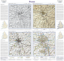
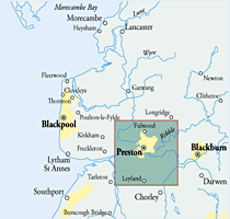
This map includes the following locations
Abbeystead,
Anchorsholme,
Ansdell,
Bailrigg,
Ballam, Lower,
Bamber Bridge,
Bank Houses,
Banks,
Bartle, Lower,
Barton,
Bay Horse,
Becconsall,
Bilsborrow,
Bispham,
Bispham, Little,
Black Pole,
Blackleach,
Blackpool,
Bleasdale,
Bolton Houses,
Bonds,
Bottom of Hutton,
Bowgreave,
Breedy Butts,
Bretherton,
Brindle,
Broadfield,
Brock,
Brook Bottom,
Brookfield,
Broughton,
Bryning,
Burn Naze,
Cabus,
Cadley,
Calder Vale,
Carleton,
Carleton, Little,
Catforth,
Catterall,
Churchtown,
Claughton,
Clayton Brook,
Clayton Green,
Clayton-le-Woods,
Cleveleys,
Clifton,
Cocker Bar,
Cockerham,
Cold Row,
Common Edge,
Conder Green,
Copp,
Copthurst, Lower,
Corner Row,
Cottam,
Coup Green,
Cow Hill,
Crossmoor,
Cuddy Hill,
Cuerden Green,
Cumeragh Village,
Dam Side,
Dolphinholme,
Dowbridge,
Duncombe,
Eagland Hill,
Earnshaw Bridge,
Eccleston, Great,
Eccleston, Little,
Ellel,
Elswick,
Elswick Leys,
Esprick,
Far Banks,
Farington,
Farington,
Farington Moss,
Fiddler's Ferry,
Fishwick,
Five Lane Ends,
Fleetwood,
Ford Green,
Forton,
Freckleton,
Frenchwood,
Fulwood,
Galgate,
Garstang,
Glasson,
Goose Green,
Goosnargh,
Grange,
Great Eccleston,
Great Marton,
Great Marton Moss,
Great Plumpton,
Greenhalgh,
Gregson Lane,
Grimsargh,
Haighton Green,
Haighton Top,
Hale Nook,
Hall Cross,
Hall Green,
Hambleton,
Hambleton Moss Side,
Hampson Green,
Hardhorn,
Hare Appletree,
Hawes Side,
Hesketh Bank,
Hesketh Moss,
Hey Houses,
Higher Ballam,
Higher Bartle,
Higher Penwortham,
Higher Walton,
Hollins Lane,
Holme Slack,
Hoohill,
Hoole Moss Houses, Little,
Hoole Moss Houses, Much,
Hoole Town, Much,
Hoole, Much,
Howick Cross,
Hundred End,
Hutton,
Inglewhite,
Ingol,
Inskip,
Inskip Moss Side,
Jack Green,
Johnson's Hillock,
Kellamergh,
Kingsfold,
Kirkham,
Knott End-on-Sea,
Lane Heads,
Larbreck,
Larches,
Layton,
Layton, Little,
Lea,
Lea Town,
Lewth,
Leyland,
Lightfoot Green,
Little Bispham,
Little Carleton,
Little Eccleston,
Little Hoole Moss Houses,
Little Layton,
Little Marton,
Little Plumpton,
Little Poulton,
Little Singleton,
Little Thornton,
Longton,
Longton, New,
Lostock Hall,
Lower Ballam,
Lower Bartle,
Lower Copthurst,
Lower Penwortham,
Lower Thurnham,
Lucas Green,
Lytham,
Lytham St Anne's,
Marsh Houses,
Marton Moss Side,
Marton Moss, Great,
Marton, Great,
Marton, Little,
Matshead,
Medlar,
Mereside,
Middleforth Green,
Middleton,
Midge Hall,
Moor End,
Moor Side,
Moor Side,
Moss Edge,
Moss Edge,
Moss Side,
Moss Side,
Mowbreck,
Much Hoole,
Much Hoole Moss Houses,
Much Hoole Town,
Mythop,
Nateby,
New Longton,
Newsham,
Newton,
Newton with Scales,
Nog Tow,
Norbreck,
Norcross,
Normoss,
North Shore,
Oakenclough,
Ortner,
Out Rawcliffe,
Overton,
Peel,
Peel Hill,
Penwortham Lane,
Penwortham, Lower,
Pilling,
Pilling Lane,
Pippin Street,
Plumpton, Great,
Plumpton, Little,
Potters Brook,
Poulton, Little,
Poulton-Le-Fylde,
Preesall,
Preesall Park,
Preston,
Pudding Pie Nook,
Queenstown,
Quernmore,
Ratten Row,
Red Scar,
Ribbleton,
Ribby,
Riverside Docklands,
Roach Bridge,
Roseacre,
Saltcotes,
Samlesbury,
Sand Side,
Scorton,
Scotforth,
Scronkey,
Seed Lee,
Sharoe Green,
Shore, North,
Shore, South,
Singleton,
Singleton, Little,
Skippool,
Skitham,
Smallwood Hey,
Smith Green,
South Shore,
Sower Carr,
Squires Gate,
St. Annes,
St. Michael's on Wyre,
Staining,
Stalmine,
Stalmine Moss Side,
Stanah,
Staynall,
Stodday,
Street,
Stubbins,
Sunderland,
Swillbrook,
Tanterton,
Tardy Gate,
Tarleton,
Tarleton Moss,
Tarnbrook,
Thistleton,
Thornton,
Thornton, Little,
Thorpe Green,
Thurnham, Lower,
Thurnham, Upper,
Top o'th' Lane,
Treales,
Trunnah,
Upper Thurnham,
Wade Hall,
Walmer Bridge,
Walton Summit,
Walton-le-Dale,
Warbreck,
Warton,
Warton Bank,
Weeton,
Wesham,
Westby,
Wharles,
Whin Lane End,
White Stake,
Whitechapel,
Whiteholme,
Whittle-le-Woods,
Willacy Lane End,
Winmarleigh Moss,
Woodplumpton,
Woodsfold,
Wrea Green,
Wymott,
|