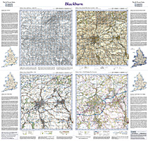
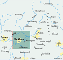
This map includes the following locations
Abbey Village,
Accrington,
Aire View,
Airton,
Altham,
Bacup,
Balderstone,
Balladen,
Bank Fold,
Bank Hey,
Bank Newton,
Barley,
Barley Green,
Barnoldswick,
Barrow,
Barrowford,
Bashall Eaves,
Bashall Town,
Baxenden,
Bay Gate,
Beardwood,
Bell Busk,
Belthorn,
Bent Gate,
Billington,
Blackburn,
Blacko,
Blackshaw Head,
Blacksnape,
Boarsgreave,
Bolton-by-Bowland,
Booth Bridge,
Bracewell,
Bradford, West,
Brierfield,
Brinscall,
Britannia,
Broad Clough,
Broadfield,
Brookhouse,
Broughton,
Brownhill,
Brownside,
Brunshaw,
Burnley,
Burnley Lane,
Burnley Wood,
Calton,
Carleton,
Castle Street,
Chapels,
Charlestown,
Chatburn,
Cherry Tree,
Chipping,
Church,
Church Clough,
Clayton Le Dale,
Clayton-Le-Moors,
Cliffe,
Clitheroe,
Clough Foot,
Clough, Broad,
Cloughfold,
Clow Bridge,
Coates,
Cockden,
Colden,
Colne,
Colne Edge,
Coniston Cold,
Cononley,
Cononley Woodside,
Constable Lee,
Copster Green,
Cornholme,
Cotton Tree,
Cow Ark,
Cowling,
Cowpe,
Crawshawbooth,
Cribden Side,
Dale End,
Darwen,
Darwen, Lower,
Dean,
Dill Hall,
Dinckley,
Downham,
Dunnockshaw,
Dunsop Bridge,
Earby,
Earcroft,
Easington,
East Marton,
Eastwood,
Edge End,
Edgeside,
Elslack,
End, West,
Eshton,
Ewood,
Ewood Bridge,
Fair Oak,
Fence,
Feniscliffe,
Feniscowles,
Field, High,
Flasby,
Flax Moss,
Forest Becks,
Forest Holme,
Foulridge,
Four Lane End,
Gargrave,
Gill,
Gisburn,
Goodshaw,
Goodshaw Chapel,
Goodshaw Fold,
Great Harwood,
Great Mitton,
Greave,
Green End,
Green Haworth,
Grimshaw,
Grindleton,
Grunsagill,
Guide,
Habergham,
Haggate,
Hall Hey, New,
Halton West,
Hapton,
Harle Syke,
Harwood, Great,
Harwood, Little,
Haslingden,
Hawks Stones,
Hebden Bridge,
Height End,
Hellifield,
Hellifield Green,
Helmshore,
Heptonstall,
Hesketh Lane,
Hetton,
Hey,
High Field,
Higham,
Higher Audley,
Higher Croft,
Higher Hogshead,
Higher Wheelton,
Higherford,
Hillock Vale,
Hindle Fold,
Hoddlesden,
Hoghton,
Hoghton Bottoms,
Holden,
Hole Bottom,
Hollin Hall,
Holme Chapel,
Horrocksford,
Horton,
Howgill,
Hud Hey,
Hugh Mill,
Huncoat,
Hurst Green,
Hurstwood,
Huttock Top,
Hyndburn Bridge,
Ickornshaw,
Intack,
Irwell Vale,
Kelbrook,
Knotts,
Knowl Wood,
Knowle Green,
Knuzden Brook,
Lammack,
Lane Bottom,
Lane End,
Lane Ends,
Lane Ends,
Lane Ends,
Lane Side,
Laneshaw Bridge,
Langho,
Langho, Old,
Laund,
Leemings,
Little Harwood,
Little Marsden,
Little Moor,
Little Moor End,
Little Town,
Lomeshaye,
Long Preston,
Longridge,
Lothersdale,
Love Clough,
Low Moor,
Low Snaygill,
Lower Darwen,
Lowerford,
Lowerhouse,
Lumb,
Lumbutts,
Lydgate,
Mankinholes,
Marsden Height,
Marsden, Little,
Marton, East,
Marton, West,
Mellor,
Mellor Brook,
Mereclough,
Middleton,
Midgehole,
Mill Hill,
Milnshaw,
Mitton, Great,
Moor End, Little,
Moor, Little,
Moor, Low,
Myerscough Smithy,
Mytholm,
Nab's Head,
Nappa,
Nelson,
Nethertown,
New Hall Hey,
New Road Side,
New Row,
New Town,
Newbridge,
Newby,
Newchurch,
Newchurch in Pendle,
Newsholme,
Newton,
Nun Hills,
Oakenshaw,
Old Langho,
Old Town,
Ollerton Fold,
Osbaldeston,
Osbaldeston Green,
Oswaldtwistle,
Otterburn,
Over Town,
Padiham,
Park Close,
Paythorne,
Pecket Well,
Pendleton,
Pickup Bank,
Pike Hill,
Pimlico,
Pleasington,
Pleckgate,
Portsmouth,
Preston, Long,
Pudsey,
Queen's Park,
Rake Head,
Ramsden Wood,
Rathmell,
Rawtenstall,
Raygill,
Read,
Reedley,
Reeds Holme,
Revidge,
Ribchester,
Riley Green,
Rimington,
Rishton,
Rising Bridge,
Road Side, New,
Rockcliffe,
Rodmer Clough,
Roe Lee,
Rose Grove,
Rose Hill,
Rosehill,
Rossendale,
Roughlee,
Row, New,
Rylstone,
Sabden,
Salesbury,
Salterforth,
Samlesbury Bottoms,
Sawley,
Scaitcliffe,
Shackleton,
Shade,
Shadsworth,
Sharneyford,
Shawforth,
Sherfin,
Shore,
Simonstone,
Skipton,
Slack,
Slaidburn,
Snaygill, Low,
Spring Green,
Spring Hill,
Stacksteads,
Standen Hall,
Stanhill,
Stirton,
Stock,
Stone Head,
Stopper Lane,
Stydd,
Sunny Bower,
Sunnyhurst,
Swinden,
Sykes,
Thorlby,
Thornton-in-Craven,
Tockholes,
Todmorden,
Tosside,
Tottleworth,
Town Head,
Town, Little,
Town, New,
Town, Old,
Town, Over,
Townsend Fold,
Trawden,
Trough Gate,
Turner Green,
Twiston,
Vale,
Waddington,
Walk Mill,
Walker Fold,
Walsden,
Ward Green Cross,
Warland,
Water,
Waterfoot,
Waterloo,
Waterside,
West Bradford,
West End,
West Marton,
Whalley,
Whalley Banks,
Wheatley Lane,
Wheelton,
Whinny Heights,
Whitebirk,
Whitehall,
Whitewell,
Whitewell Bottom,
Wigglesworth,
Wilpshire,
Winewall,
Winterburn,
Wiswell,
Withnell,
Withnell Fold,
Wood House,
Woodnook,
Worsthorne,
Worston,
Wycoller,
York,
|