Malton & Pickering HMG (1857-1925)
 |
|||||
|
|
|||||
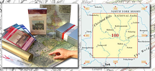
| Historical Map Gift Set (100) - Malton & Pickering HMG (1857-1925) This Historical Map Gift Set comprises:
|
More Details >>
| Cassini Maps | ||||||||
| Malton & Pickering HMG (1857-1925) | ||||||||
Malton & Pickering HMG (1857-1925) |
||||||||
More Details >> |
This map includes the following locations Acklam, Aislaby, Aldwark, Alne, Alne Station, Amotherby, Ampleforth, Appleton-le-Moors, Appleton-le-Street, Bagby, Barton Hill, Barton-le-Street, Barton-le-Willows, Barugh, Great, Barugh, Little, Beadlam, Birdforth, Birdsall, Boltby, Bossall, Brandsby, Brawby, Broughton, Bulmer, Burythorpe, Butterwick, Byland Abbey, Byland, Old, Carlton, Carlton Husthwaite, Cawthorne, Cawton, Chop Gate, Church Houses, Claxton, Cockayne, Cold Kirby, Coneysthorpe, Coulton, Cowesby, Coxwold, Crambe, Crambeck, Crayke, Cropton, Cross Holme, Cross Lanes, Dalby, Dalby, Low, Easingwold, East Ness, East Newton, Edstone, Great, Ellerburn, Fadmoor, Fangdale Beck, Farlington, Felixkirk, Firby, Flawith, Flaxton, Foston, Fryton, Ganthorpe, Gillamoor, Gilling East, Grange, The, Great Barugh, Great Edstone, Great Habton, Great Thirkleby, Grimston, North, Habton, Great, Habton, Little, Harome, Hartoft End, Harton, Hawnby, Helmsley, High Hutton, High Kilburn, High Marishes, Holme, South, Hovingham, Howsham, Huby, Husthwaite, Hutton Sessay, Hutton, High, Hutton, Low, Hutton-le-Hole, Huttons Ambo, Keldholme, Kennythorpe, Kepwick, Kilburn, Kilburn, High, Kirby Knowle, Kirby Misperton, Kirkby Mills, Kirkbymoorside, Kirkham, Langton, Lastingham, Leavening, Leppington, Levisham, Lilling, West, Linton-on-Ouse, Little Barugh, Little Habton, Lockton, Low Dalby, Low Hutton, Low Marishes, Low Mill, Lowna, Malton, Malton, Old, Marishes, High, Marishes, Low, Marton, Marton-in-the-Forest, Menethorpe, Middlecave, Middleton, Mill, Low, Moxby, Murton Grange, Muscoates, Nawton, Ness, East, Ness, West, Newbridge, Newton, East, Newton-on-Rawcliffe, Normanby, North Grimston, Norton, Nunnington, Old Byland, Old Malton, Oldstead, Oswaldkirk, Oulston, Pickering, Pockley, Raskelf, Rievaulx, Rillington, Rosedale Abbey, Ryton, Salton, Scackleton, Scagglethorpe, Scawton, Scrayingham, Settrington, Sheriff Hutton, Sinnington, Skewsby, Slingsby, South Holme, Spaunton, Sproxton, Stape, Stearsby, Stillington, Stonegrave, Strensall, Sutton-on-the-Forest, Sutton-under-Whitestonecliffe, Swinton, Terrington, The Grange, Thirkleby, Great, Thirlby, Thixendale, Tholthorpe, Thorgill, Thormanby, Thornton-le-Clay, Thornton-le-Dale, Tollerton, Wass, Wath, Welburn, Welburn, West Lilling, West Ness, Westow, Wharram Percy, Whenby, Whitewall Corner, Whitwell-on-the-Hill, Wiganthorpe, Wombleton, Wrelton, Wykeham, Yearsley, Youlton, |
This Version: |
| Malton & Pickering HMG (1857-1925) - HMG-100 |