Dorking & Reigate HMG (1813-1920)
 |
|||||
|
|
|||||
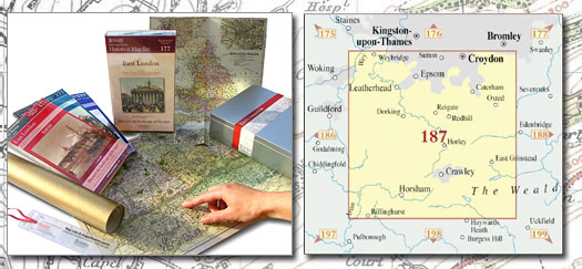
| Historical Map Gift Set (187) - Dorking & Reigate HMG (1813-1920) This Historical Map Gift Set comprises:
|
More Details >>
| Cassini Maps | ||||||||
| Dorking & Reigate HMG (1813-1920) | ||||||||
Dorking & Reigate HMG (1813-1920) |
||||||||
More Details >> |
This map includes the following locations Abinger Common, Abinger Hammer, Addington, Addington, New, Albury, Albury Heath, Aperfield, Ashtead, Ashtead, Lower, Baldwins Hill, Bandonhill, Banstead, Barwell, Beare Green, Beddington, South, Belmont, Berry's Green, Betchworth, Biggin Hill, Black Corner, Blackbrook, Blackwell, Bletchingley, Blindley Heath, Bookham, Great, Bookham, Little, Box Hill, Brandon Hill, Brewer Street, Bridge End, Broadham Green, Broadmoor, Brockham, Brockham Park, Brook, Brooklands, Buckland, Bucks Green, Bunce Common, Burgh Heath, Burrows Cross, Burstow, Burwood Park, Bushbury, Byfleet, Capel, Carshalton, Carshalton Beeches, Carshalton on the Hill, Caterham, Chaldon, Charlwood, Cheam, Chelsham, Chessington, Chipstead, Church End, Church Town, Clandon, East, Claremont Park, Clark's Green, Claygate, Clock House, Cobham, Coldharbour, Coles Meads, Coney Hall, Copthorne, Coulsdon, Coulsdon, Old, Crabbet Park, Cranleigh, Crawley Down, Crockham Hill, Crowhurst, Crowhurst Lane End, Croydon, Croydon, South, Cudham, Cudworth, Dawesgreen, Deepdene, Domewood, Dorking, Dormans Park, Dormansland, Doversgreen, Down Park, Downe, Downside, Downside, Earlswood, Earlswood, South, East Clandon, East Ewell, East Grinstead, East Horsley, Edenbridge, Effingham, Effingham Park, Elm Corner, End, North, End, West, Epsom, Esher, Ewell, Ewell, East, Ewell, West, Ewhurst, Ewhurst Green, Fairmile, Farleigh, Farleigh Court, Farley Green, Farnborough, Felbridge, Felcourt, Fernhill, Fetcham, Fickleshole, Force Green, Forest Green, Forestdale, Fredley, Friday Street, Froghole, Furnace Wood, Gadbrook, Gatton, Givons Grove, Godstone, Godstone, South, Gomshall, Goodley Stock, Great Bookham, Green, West, Grinstead, East, Ham Moor, Hammerwood, Hamsey Green, Haven, The, Haw, New, Hawk's Hill, Haxted, Hazelwood, Headley, Heath, Little, Heathfield Estate, Hersham, Hill Park, Hoe, Holland, Holmbury St Mary, Holmethorpe, Holmwood Corner, Holmwood, North, Holmwood, South, Hook, Hookwood, Hooley, Horley, Horne, Horsley, East, Horsley, West, Hurst Green, Ifield, Ifield Green, Ifieldwood, Irons Bottom, Kenley, Keston, Kingswood, Kingswood, Lower, Lacey Green, Langley Green, Langley Vale, Layhams, Leatherhead, Leatherhead Comm, Leaves Green, Leigh, Limpsfield, Limpsfield Chart, Limpsfield Common, Lingfield, Lingfield Common, Little Bookham, Little Heath, Little Woodcote, Logmore Green, Looe, North, Lower Ashtead, Lower Kingswood, Lowfield Heath, Luxted, Malden Rushett, Margery, Marlpit Hill, Marsh Green, Martyr's Green, Mayes Green, May's Green, Mead Vale, Meath Green, Merle Common, Merstham, Merstham, South, Mickleham, Mid Holmwood, Mogador, Moorhouse Bank, Mugswell, Nalderswood, Nash, New Addington, New Haw, Newchapel, Newdigate, Nork, North End, North Holmwood, North Looe, Northgate, Norwood Hill, Nutfield, Nutfield, South, Oakwoodhill, Oatlands Park, Ockham, Ockley, Old Coulsdon, Outwood, Oxshott, Oxted, Pachesham Park, Pains Hill, Park, South, Parkgate, Paynes Green, Peaslake, Pixham, Polesden Lacey, Pound Hill, Povey Cross, Purley, Ranmore Common, Ravensbourne, Redhill, Reigate, Reigate Heath, Ridge Green, Ripley, Rose Hill, Roundshaw, Rudgwick, Rusper, Russ Hill, Russell Hill, Salfords, Sanderstead, Selsdon, Shellwood Cross, Shere, Shipley Bridge, Shirley, Upper, Sidlow, Single Street, Smallfield, South Beddington, South Croydon, South Earlswood, South Godstone, South Holmwood, South Merstham, South Nutfield, South Park, South Street, St. George's Hill, Stoats Nest Village, Stoke D' Abernon, Stonebridge, Stoneleigh, Stonequarry, Street, South, Strood Green, Sunnyside, Sutton, Sutton Abinger, Tadworth, Tandridge, Tatsfield, The Haven, The Wells, Three Bridges, Tinsley Green, Tisman's Common, Titsey, Tower Hill, Troy Town, Tyler's Green, Tyrell's Wood, Upper Shirley, Wallington, Walliswood, Walton on the Hill, Warlingham, Warwick Wold, Wasp Green, Waterside, Weatherhill, Wells, The, West End, West Ewell, West Green, West Horsley, Westcott, Westerham, Westhumble, Weybridge, Whitebushes, Whiteley Village, Whyteleafe, Wisley, Woldingham, Woldingham Garden Village, Woodcote, Woodcote, Woodcote Green, Woodcote, Little, Woodhatch, Woodmansterne, Wotton, Wray Common, |
This Version: |
| Dorking & Reigate HMG (1813-1920) - HMG-187 |